
I took a break from Whiting Ranch to explore the season at nearby O’Neill Regional Park, specifically the Live Oak, the Hoffmann Homestead, and the Vista Trails, a lariat that I began at the corner of Meadow Ridge and Chisolm Trail in Mission Viejo. Summer is the season of death here in Orange County. Memorial Day weekend marks the final demise of the foxtail and wild oat grasses. Gone are the Golden Stars, the mustard, and other competitors for the sun of the open range. The country turns resplendent yellow except for dusky patches of sage, toyon, and chamise creating a pattern on the hills.
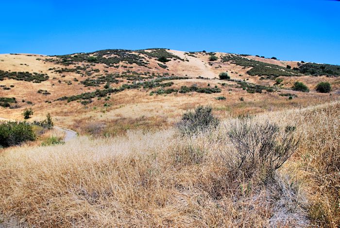
Vedanta Wilderness, O’Neill Regional Park, California
Few things can be more frustrating that to aim your eye through your camera’s viewfinder and discover that its battery has died just as a brilliant vista comes into view. This happened to me as I surmounted the hill near the Vista Point and looked down on the Live Oak Trail as it plunged down one slope and crawled up the long ridge that rises after the junction with the Coyote Trail. I sighed and contained a tantrum by remembering that I had my Samsung S5 in my pocket. It couldn’t compete with my Nikon, but it was better than nothing.
The atmosphere was rainless and nearly crystalline. I snapped a few photos for Instagram, but soon regretted the slumber of my DSLR when I stepped off the Live Oak and started to circle back via the Hoffman Homestead Trail. The live oaks, chaparro, and toyons shaded wildflowers from the scorch of the sun. I saw Mexican pinks (cardinal catchflys), Splendid Mariposa lilies, Weed’s Mariposa lilies, Orange Bush Monkeyflowers, and some popcorn flowers that had survived the torrid last weeks of May. Scarlet streaks reddened the poison oak that leaned into the path as vines, shrubs, and sometimes trees. I wove down the trail so as to avoid the last of these,then began the climb to the Vista Point.
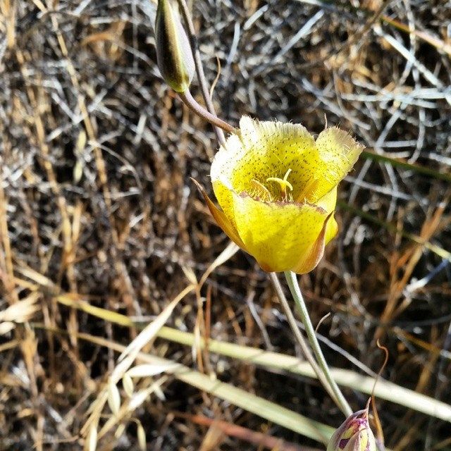
Weed’s Mariposa Tulip, O’Neill Regional Park, California
The park management at O’Neill believe that this foot-and-a-half wide trail can accommodate horses, bikes, and foot traffic. It is one of the few places I find myself screaming at mountain bikers — who speed down its switchbacks at velocities in excess of the posted 10 miles per hour. More than once I have been nearly run down by a free-falling cyclist who forgot the brown triangle at the top of the trail which directs that mountain bikers are to give the right of way to hikers and both of these to horses. In a feeble attempt at fairness, I shall say that there really isn’t any place for the bikers to pull over. If this is the case, however, the trail should be closed to the wheel and, perhaps, the hoof.
The steepness of the Vista Point Trail compelled me to stop a few times to catch my breath. (A friend of mine has noted that I have the painful habit of making my rest stops in the sun instead of in the shade. The shade can be nice, but the vegetation also blocks the cool breezes that come from the sea.) My last stop was a few steps short of the top where I heard high-pitched adolescent chatter. Some teenaged mountain bikers struggled to catch their breath at the picnic table. The least exhausted of the bunch pointed his cell phone at the cloudless sky, perhaps to capture a perfect sapphire blue. One of the resting teens asked “Did you get any good pictures?”
“I don’t know,” I said. “Camera battery died.”
“That’s too bad.”
“Yeah. It sucks.”
I walked a few paces then pulled out my cell phone for one last shot of the Saddleback. Then I walked back down the Live Oak Trail to where I had parked in the shade. My eyes remained focused on the ground as I counted my steps and dodged a single mountain biker who I left ample room to maneuver around me. “There are no pictures when I am not looking,” I said to myself. Even the pebbles on the trail vouched that mantra for a lie.
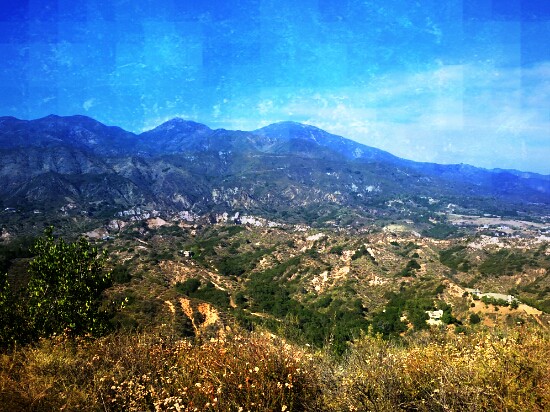
The Saddleback from the Vista Point, O’Neill Regional Park, California
DIRECTIONS: From Interstate 5, head north on El Toro to Valley Vista. Turn right. Follow Valley Vista as it turns into Meadow Ridge. At the end of Meadow Ridge (where it intersects with Chisolm Trail), park your car. The trailhead is straight ahead.
ROUTE: Follow the Live Oak Trail (it’s a long way) to Hoffman Homestead. Take Hoffman Homestead to Vista Trail. (Again this is a longish trail.) Climb the Vista Trail to the Vista Point, check out the scenery, and keep going to the Live Oak Trail. Follow the Live Oak Trail back the way you came.
The location of this trail can be found on the Orange County Back Country map.
