
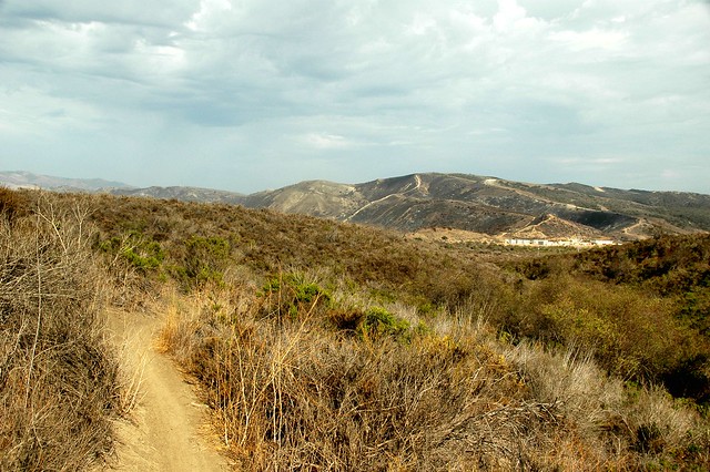
Peaceful Valley with Camp Pendleton in the background
“You’re the first person we’ve seen on this trail this afternoon,” I said to the mountain biker riding toward me.
“There’s a woman hiking alone back there,” he said.
“That’s my wife,” I said. “We’re turning back.” I put my walkie talkie to my mouth and gave Lynn the news. We’d done enough of this trail. The sun was beginning to come down and there was just more of the empty sage scrub and dead meadows that had accompanied our footsteps from the start of our walk in the back country portion of San Onofre State Beach.
Back country? I had seen the plot on a map running up alongside the northwestern edge of Camp Pendleton or “Marine Land” as I liked to call it. The pan handle that was the only inland broken segment of the state park began just north of Trestles, crossed the road and ended up at the edge of a San Clemente neighborhood. The nontopographical depiction in the park brochure showed a tangle of trails with only two — the Peaceful Valley and the Ancestors Trail — named explicitly. All trails curved to the northwest just shy of the point where Cristianitos Road came to the base gate.
We parked our car down the road from all this — at the edge of the area where surfers enjoy free parking for Trestles Beach. The trail began with a breach in the guardrails and went against the flow of beach-bound campers. Enroute to San Mateo Campground we saw the first examples of what is best described as a stupid Marine trick: To mark their departure from the service, jarheads tied the laces of their boots together and threw them over the power lines. I had seen dozens dangling in the past, but the Corps or Southern California Edison must have cleaned up the lines because I only counted six or seven pair.
Finding our way to the campground was easy enough but finding our way out of it was hard. A false lead up the road from the entrance drew us to a dead end. We backtracked to a construction equipment yard marked “Authorized Vehicles Only” and probed the edges until we found a yellow gate. Fifty paces in, a faded sign in both English and Spanish warned that we were entering a live gunfire area. Though I considered going back to yell at the ranger at the campground entrance, I satisfied myself with a simple “fuck this” and kept going. The only evidence of the firing range were dusty black and red piles of broken skeet. We kept going past driveways that led off to electrical towers. Then the path narrowed into a grooved single track.
I dubbed it “OC’s most secret trail”. We saw no one other than the mountain biker. The miles went on over wooden slat bridges that looked like ladders and dirt that turned from pale cream to cocoa and back to cream. Drought rubbed the land clean of most plant life. Dead sagebrush lined the path, its streaks of faded green intertwining with skeletal silver. I found a lemonade berry bush glistening with citric fruit. A fair variety of birds fluttered in the scrub. Sightings of mourning doves, savannah sparrows, and lesser goldfinches plus a small, dark mystery bird were recorded in my nature notebook. Lizards — my constant friends on most chaparral trails — were absent. The route was poorly marked — no, it was not marked at all! The trail forked, spread, and sometimes met itself further on without so much as a signpost. I had no map in hand, so I guessed which turns to make. Now and then I had to backtrack, but we found our way.
Our objective was a cross marking the site of the first Christian baptism in California. It turned out to be on Camp Pendleton land. A fence topped with barbed wire persuaded me that there was no getting to the landmark, so I gave the signal to turn back.
Lynn and I had had enough of the windings of the trail. It had been a tedious trek through bland country with no destination. Our legs and joints ached. The sun had begun its plummet into the sea. We abandoned the Peaceful Valley Trail for the hard-packed, asphalt certainty of Cristianitos Road with its souped-up trucks and cheap sports cars driven by speed-freaking jarheads. I photographed roadside grasses backlit by the sun, a cluster of buildings said to be a training ground for the Iraq War, and some black and red Harlequin beetles clinging to the dead thorns of black mustard. We ignored the leathernecks revving their engines and honking as we stayed well to the side, walking along the straight highway until we saw our car and tasted the promise of the Morroccan chicken stew that I had left simmering in the slow cooker.
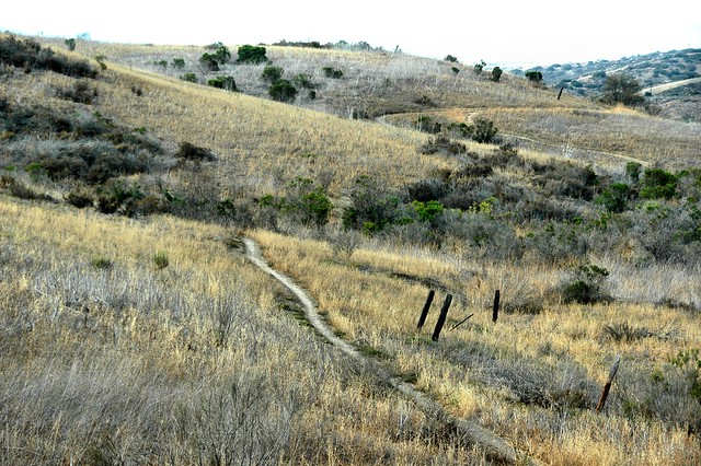
Peaceful Valley Trail

Stupid Marine Trick
DIRECTIONS: You really want to go here? Well, maybe in the spring there will be wildflowers. Take the San Diego Freeway to the Cristianitos Road exit and head inland (east.) Just past El Camino Real, start looking for a parking place on the left. (Make a shameless U-Turn.) Watch the no parking signs carefully. You will want to get on the southeast side of the road and look for the gap in the guardrail. Wave at all the endangered pocket mice on Pocket Mice Hill across the road, then take the path to the campground. Once you are in the campground, find the entrance station. Congratulate yourself on the fact that by parking on the street you saved $15, then cross the road to the “Authorized Vehicles Only” yard and find the yellow gate. Begin your hike.
